Deskripsi
Download Brosur : Brosur GPS Geodetik/GNSS Hi Target vRTK
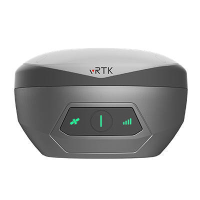
GPS Geodetic Hi Target vRTK merupakan perangkat GNSS yang menggunakan metode RTK dengan fungsionalitas Inertial Measurement Unit (IMU) dan dilengkapi dengan teknologi visual positioning, fitur yang masih jarang ditemukan pada GPS Geodetic lainnya.
Alat ini mempunyai ukuran bodi yang kecil sehingga dapat disimpan di saku atau saku surveyor. Selain bobotnya yang ringan, vRTK dengan teknologi positioning berbasis kamera menjadikan GPS geodetik terbaik di kelasnya.
Hal ini memungkinkan pengguna, baik surveyor maupun staf teknis, mengumpulkan informasi dengan mudah dan meningkatkan akurasi posisi. Oleh karena itu kualitas dari alat ini sudah tidak diragukan lagi.
Beli juga : Automatic Level Waterpass Nikon AX-2S
Indosurta Banjarmasin jual GPS Geodetic / GNSS Hi Target vRTK dengan harga murah dan bergaransi resmi 1 tahun. Untuk pembelian silakan hubungi kami atau bisa juga datang ke toko alat survey kami.
Spesifikasi GPS Geodetic / GNSS Hi – Target vRTK
- Satellite Signals Tracked Simultaneously
- Channels: 1408/800+ (Optional)
- GPS: L1CA / L1C / L2P(Y) / L2C / L5
- BDS: B1l / B2l / B3l / B1C / B2a / B2b*
- GLONASS: L1/L2/L3
- Galileo: E1 / E5a / E5 / AltBOC / E5b / E6
- SBAS: L1C/A, L5(QZSS, WAAS, MSAS, GAGAN)
- QZSS: L1 / L2 / L5 / L6*
- IRNSS: L5
Positioning Performance
- High Precision static
- Horizontal : 2.5mm + 0.1ppm RMS
- Vertical: 3.5mm + 0.4ppm RMS
- High Precision static
- Static and Fast Static
- Horizontal: 2.5mm + 0.1ppm RMS
- Vertical: 3.5mm + 0.4ppm RMS
- Static and Fast Static
- Post Processing Kinematic (PPK / Stop & Go)
- Horizontal: 8mm + 1ppm RMS
- Vertical: 15mm + 1ppm RMS
- Initialization time: Typically 10 min for base and 5 min for rover
- Initialization reliability: Typically > 99.9%
- Post Processing Kinematic (PPK / Stop & Go)
- Code Differential GNSS Positioning
- Horizontal: ±0.25m + 1ppm RMS
- Vertical: ±0.5m + 1 ppm RMS
- SBAS: 0.5m
- Code Differential GNSS Positioning
- Real Time Kinematic (RTK)
- Single Baseline
- Horizontal: 8mm+1ppm RMS
- Vertical: 15mm+1ppm RMS
- Single Baseline
- Network RTK(VRS, FKP, MAC)
- Horizontal: 8mm+0.5ppm RMS
- Vertical: 15mm +0.5ppm RMS
- Initialization Time: Typically 2-10s
- Initialization Reliability: Typically > 99.99%
- Provides RTK measurement even during differential signal interruptions
- Network RTK(VRS, FKP, MAC)
- Hi-Fix
- Horizontal: RTK+10mm / minute RMS
- Vertical: RTK+20mm / minute RMS
- Hi-Fix
- Time to first Fix
- Cold Start: <45 s
- Hot Start: < 30 s
- Signal re-acquisition: < 2 s
- Time to first Fix
- Image Accuracy
- Stakeout: Typically 2cm
- Image measurement: 2cm~4cm
- Image Accuracy
- Tilt Survey Performance
- Additional horizontal pole-tilt uncertainty typically less than 8mm+0.7mm/°tilt(2.5cm accuracy in the inclination of 60°)
- Tilt Survey Performance
Hardware
- Physical
- Dimensions (W x H): 130mm x 79mm
- Wieght: lighter than 0.97kg (2.14lb) within internal battery
- Operation temperature: -40°C~+75°C (-40°F~+167°F)
- Storage temperature: -55°C~+85°C (-67°F~+185°F)
- Temperature Control: Auto-adjust the working power to maintain the temperature
- Humidity: 100% non-condensing
- Water/dustproof: IP68, protected from temporary immersion to depth of 1.0m (3.28ft)
- Shock and vibration: MIL-STD-810G, 514.6
- Anti-salt spray: MIL-STD-810G, 509.4, 96h
- Free fall: MIL-STD-810G, 516.6, designed to survive a 2m(6.56ft) natural fall onto concrete
- Physical
- Charging
- Charging: using standard smartphone chargers or external power banks (support 5V 2.8A Type-C USB External Charging)
- Charging
- Control Panel
- Physical Button: 1
- LED Lights: Satellite lights, signal lights, power lights
- Control Panel
- Camera
- Pixel: 2MP & 5MP Support real scene stakeout, image measurement, working distance 2~15m
- Camera
- Internal Battery
- 7.2V, 6900mAh, Built-in lithium-ion Battery.
- RTK rover(UHF/Celullar) for 15 hours.
- Power indicator embedded.
- Quick charge within 3.5 hours.
- Internal Battery
- I/O Interface
- Bluetooth 4.0/2.1+EDR, 2.4GHz USB Type C interface; SMA interface;
- Nano SIM card slot
- Near Field Communication (NFC)
- I/O Interface
Communication
- Network Communication
- Full band support for cellular mobile network(LTE, WCDMA, EDGE, GPRS, GSM). 2.4GHz Wi-Fi, supports the standard protocol 802.11 b/g/n. Network RTK(in CORS) range is 20-50km.
- Network Communication
- Internal UHF Transceiver Radio
- Frequency: 410~470MHz
- Transmitting Power: 0.5W / 1W / 2W adjustable Hi-Target
- Support protocols: HI-TARGET, TRIMTALK450S, TRIMMARK III, SATEL-3AS, TRANSEOT, etc.
- Working Range: Typically 3-5km, optimal 5~8km
- Channels: 116
- Internal UHF Transceiver Radio
System Configuration
- System
- Data Storage: Circulating 8GB Internal Storage, Record GNS and RINEX format simultaneously
- System
- Data Formats
- 1Hz positioning output, up to 20Hz. RTCM2.X, RTCM3.X.
- Navigation outputs ASCII: NMEA-0183
- Data Formats
Layanan purna jual
- Garansi servis 1 tahun
- Gratis training alat
- Gratis pengiriman dan juga COD khusus Kota Banjarmasin dsk
Alasan mengapa memilih Indosurta?
- Lebih dari 10 Tahun berpengalaman di dunia survey dan pemetaan.
- Setiap pembelian alat di Indosurta akan mendapatkan gratis kalibrasi selama 1 tahun, dan gratis pelatihan alat.
- Produk berkualitas dan juga bergaransi resmi
Tentu saja kami juga menerima pengiriman keluar Banjarmasin
Lalu kami juga tersebar luas di kota – kota seluruh Indonesia, seperti :
- Balikpapan
- Makassar
- Batam
- Surabaya
- Palembang
- Medan
- Manado
- Cikarang
- Semarang
- Banjarmasin
- Kendari
- Jakarta
- Samarinda
Baca juga : Apa itu sistem kadaster? pengertian & peraturan