Deskripsi
Download Brosur : Brosur GPS Geodetik Hi Target V60 RTK GNSS
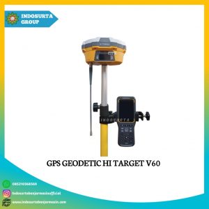
GPS Geodetic Hi-Target V60 adalah system GNSS RTK dengan desain yang lebih ringkas dan berperforma lebih tinggi. Selain dasarnya yang kokoh untuk menahan benturan dan getaran. GPS Geodetic Hi-Target V60 juga memiliki tampilan layar OLED industry pada panel control depan untuk menunjukan semua informasi dan status pekerjaan.
GPS Geodetic Hi-Target V60 merupakan GPS Geodetic yang popular digunakan di Indonesia ini. Karena GPS Geodetic Hi-Target V60 memiliki hasil pengukuran yang lebih akurat disbanding dengan GPS merk lainnya.
Beli juga : Tribrach Sokkia
Sebenarnya ada banyak jenis GPS Geodetic yang dijual dipasaran, namun harga yang ditawarkan cukup mahal dibandingkan dengan GPS Geodetic Hi-Target. Produk GPS Geodetic Hi-Target V60 yang kami jual banyak digunakan untuk keperluan pengukuran yang dilakukan oleh BPN, perusahaan BUMN atau pun SWASTA.
Spesifikasi GPS Geodetic Hi-Target V60 GNSS RTK
Measurements
- 1408 Channels (only for gnss manufactured in 2024 and above)
- High precision multiple correlator for GNSS pseudo range measurements.
- Unfiltered, unsmoothed pseudo range measurements data for low noise, low multipath error, low time
- domain correlation and high dynamic response.
- Very low noise GNSS carrier phase measurements with <1 mm precision in a 1 Hz badwidth.
- Signal to noise ratios reported in dB-Hz
Satellite Signals Tracked Simultaneously
- GPS : Simultaneous L1C/A, L2C, L2E, L5
- GLONASS : Simultaneous L1C/A, L1P, L2C/A, (GLONASS M only), L2P
- SBAS : Simultaneous L1 C/A, L5 (EGNOS, WAAS, MSAS, GAGAN, QZSS)
- Galileo : Simultaneous L1 BOC, E5A, E5B, E5AltBOC (Optional)
- BDS : B1, B2
Positioning Performance
- Hot Start : Typically <10s
- Cold Start : Typically <15s
High-precision static
- Horizontal : 2.5 mm + 0.1 ppm RMS
- Vertical : 3.5 mm + 0.4 ppm RMS
Static and Fast Static
- Horizontal : 2.5 mm + 0.5 ppm RMS
- Vertical : 3.5 mm + 0.5 ppm RMS
Post Processing Kinematic (PPK / Stop & Go)
- Horizontal : 8mm+1ppm RMS
- Vertical : 15mm+1ppm RMS
- Initialization time : Typically 10 minutes for base while 5 minutes for rover
- Initialization reliability : Typically > 99.9%
Real Time Kinematic (RTK) Surveying
- Horizontal : 8mm+1ppm RMS
- Vertical : 15mm+1ppm RMS
- Initialization time : Typically 2-10s
- Initialization reliability : Typically > 99.9%
Kelengkapan
1 Unit Base Configuation :
- Mother Board Trimble
- 1x GPS Receiver V30 1408 Chanel (SATIK+RTK)
- 2x Battery Li-Ion BL5000, 1 Unit UHF Antena Radio For RTK
- 1x Quick Charger CL 4400, 1 Unit Tribrach With GPS Adapter
- 1x Alumunium Tripod For Heavy Duty
1 Unit Rover Configuation :
- 1x GPS Receiver V60
- 2x Battery Li-Ion BL5000, 1 Unit UHF Antenna Radio For RTK
- 1x Quick Charger CL 4400, 2 Unit Bracket For Controller
- 1x Pole 2,5M Alumunium With cm Graduation Red-White
1 Unit Controler :
- 1 Unit Controler I Hand [/w 1x Battery dan 1x Unit Data]
Software :
- 1 Unit CD Software
Layanan purna jual
- Garansi servis 1 tahun
- Gratis training alat
- Gratis pengiriman dan juga COD khusus Kota Banjarmasin dsk
Baca juga : Apa yang dimaksud dengan Multipath dalam pengukuran GNSS?