Deskripsi
Download Brosur : Brosur GPS Map Garmin 66s
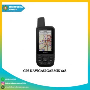
GPS Navigasi Garmin 66s siap menemani perjalanan penjelajahan anda karena perangkat GPS ini mampu memberikan informasi setiap rute yang dapat dilalui. Setiap informasi tampil pada layar transflective color TFT yang jernih.
Perangkat GPS genggam ini sudah bersertifikasi IPX7 yang tahan terhadap air sehingga anda tidak perlu takut dengan kondisi lapangan pada saat berjelajah. Oleh karena itu kualitasnya sudah tidak diragukan lagi.
Spesifikasi GPS Map Garmin 66s
General
- Physucal Dimensions: 2.5″ x 6.4″ x 1.4″ (6.2 x 16.3 x 3.5 cm)
- Disply Size: 1.5″W x 2.5″H (3.8 x 6.3 cm); 3″ diag (7.6 cm)
- Display Resolution: 240 x 400 pixels
- Display Type: transflective color TFT
- Weight: 8.1 oz (230 g) with batteries
- Battery Type: 2 AA batteries (not included) NiMH or Lithium Recommended
- Battery Life: Up to 16 hours – Up to 170 hours in expedition mode
- Water Rating: IPX7
- MIL-STD-810: yes (thermal, shock, water)
- Dengan High Sensitivity Receiver
- Interface: high speed micro USB and NMEA 0183 compatible
- Memory/History: 16 GB
Maps & Memory
- Ability To Add Maps
- Basemap
- Automatic Routing (Turn By Turn Routing On Roads) | Yes (with optional mapping for detailed roads)
- Map Segments | 15000
- Birdseye | yes (direct to divice)
- Includes Detailed Hydprographic Features (Coastlines, Lake/River Shorelines, Wetlands and Perennial and Seasonal Streams
- Includes Searchable Points of Interests (Parks, Campgrounds, Scenic Lookouts and Picnic Sites)
- Displays National, State and Lokal Parks, Forests, and Wilderness Areas
- External Memory Storage | yes (32 GB max microSD card)
- Waypoints/Favorites/Locations | 10000
- Tracks | 250
- Track Log | 20000 points, 250 saved gpx tracks, 300 saved fit activities
- Router | 250, 250 points per route 50 points auto routing
- Rinex Logging
Sensors
- GPS
- Glonass
- Galileo
- Barometric Altimeter
- Compass | Yes (tilt-compensated 3 axis)
- GPS Compass (While Moving)
Daily Smart Features
- Connect IQ (Downloadable Watch Faces, Data Fields, Widgets and Apps)
- Virb Remote
- Pairs With Garmin Connect Mobile
- Active Weather
- Smart Notifications ON Handheld
Safety and Tracking Features
- Livetrack
Outdoor Recreation
- Point To Point Navigation
- Compatible With Basecamp
- Area Calculation
- Hunt/Fish Calender
- Sun And Moon Information
- Xero Locations
- Geocaching Friendly | yes (Geocache Live)
- Custom Maps Compatible | yes (500 custome map tiles)
- Picture Viewer
- Inreach Remote Widget
- LED Beacon Flashlight
Outdoor Applications
- Compatible With Garmin Explore APP
- Garmin Explore Website Compatible
Connections
- Wireless Connectivity | yes (Wifi, Bluetooth, Ant+)
Layanan purna jual
- Garansi TAM 1 tahun
Baca juga : Bagaimana latar belakang sistem kadaster di Indonesia?