Deskripsi
Download Brosur : Brosur GPS Geodetik/GNSS Hi Target V100 RTK
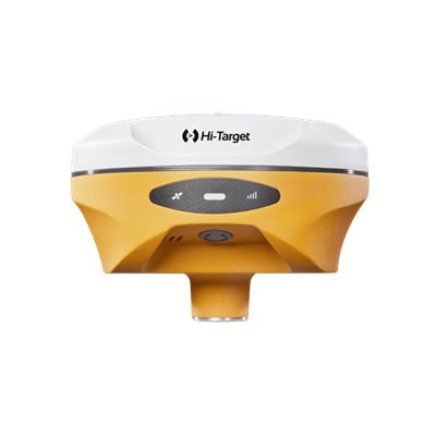
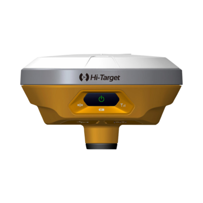
GPS Geodetic Hi Target V100 GNSS RTK dirancang khusus untuk melakukan pengukuran di area luas yang membutuhkan akurasi sangat tinggi agar mendapatkan hasil yang baik.
Alat ini dirancang untuk membuat tugas pengukuran yang membutuhkan tingkat presisi tinggi menjadi lebih mudah dan cepat di kerjakan. Memiliki desain sangat kecil, ringan, dan elegan.
Papan OEM konstelasi BD970 terintegrasi, Bluetooth jarak jauh dengan modul dual-mode 4.0 dan NFC standar, dukungan Internet pengumpulan data, dan layanan cloud Hi Target menjadikannya penerima yang paling nyaman dan efisien di era jaringan. Memberikan solusi survei GNSS RTK yang cepat, efisien, dan andal kepada pengguna.
Beli juga : Automatic Level Waterpass Topcon AT-B4A
Indosurta Banjarmasin jual GPS Geodetic Hi Target V100 GNSS RTK dengan harga murah dan bergaransi resmi 1 tahun. Untuk pembelian silakan hubungi kami atau bisa juga datang ke toko alat survey kami.
Spesifikasi GPS Geodetic Hi Target V100 GNSS RTK
Satellite Signals Tracked Simultaneously
- Channels: 1408 Channels (only for gnss manufactured in 2024 and above)
- GPS: Simultaneous L1C/A, L2C, L2E, L5
- GLONASS: Simultaneous L1C/A, L1P, L2C/A (GLONASS M only), L2P
- SBAS: Simultaneous L1 C/A, L5
- Galileo: Simultaneous E1 BOC, E5A, E5B, E5AltBOC (Reserved)
- BDS: B1, B2
- QZSS: L1 C/A, L1 SAIF, L2C, L5
Positioning Performance
- Realtime Kinematic(RTK) Surveying Network RTK
- Horizontal: 8mm+1ppm RMS
- Vertical: 15mm+1ppm RMS
- Initialization time: Typically 2-10s
- Initialization reliability: Typically > 99.9%
- Code Differential GNSS Positioning
- Horizontal: 25cm+1ppm RMS
- Vertical: 50c+1ppm RMS
- SBAS: 0.50m Horizontal, 0.85m Vertical
- High-Precision Static
- Horizontal: 2.5mm+0.1 ppm RMS
- Vertical: 3.5mm+0.4 ppm RMS
- Static and Fast Static
- Horizontal: 2.5mm+0.5 ppm RMS
- Vertical: 5mm+0.5 ppm RMS
Hardware
- Physical
- Dimension (W x H): 127.5mm x 57mm (5.02inch x 2.24 inch)
- Weight: 700g (1.54lb) including internal battery
- Operating temperature: -40°C to +65°C (-40°F to +149 °F)
- Storage temperature: -40°C to +75°C (-40°F to +167 °F)
- Humidity: 100%, condensing
- Water/dustproof: IP67 dustproof, protected from temporary immersion to depth of 2m(6.56 ft)
- Shock and vibration: Designed to survive a 3m(9.84ft) natural fall onto concrete
- Electrical
- Power Consumption: 3.2W
- Battery: Rechargeable, removable 3.7/6300mAh, lithium-ion battery, supports online charging
- Power Input: 4.5V – 5.5V/ 2A DC (USB), 6V – 28V/2A DC (5 pin port)
- Data Storage: 8GB internal storage
- Internal Battery Life
- RTK rover: 7 hours (Data collector internet)
- I/O Interface
- 1 x mini USB port: for data downloading. power supply and firmware upgrading
- 1 x 5-pin port: for NMEA output, DC power supply and external devices
- Communication
- Bluetooth: Dual-mode BT 4.0, compatible with BT 2.1, 2.4GHz
- NFC: an easy tap to establish BT connection
- Radio: Hi-Target/ Pacific Crest ADL Vantage pro external radio (optional)
- Data Formats
- Output rate: 1Hz positioning output, up to 20Hz
- Message type:
- CMR:
- CMR
- CMR+
- sCMRx input and output
- RTCM:
- RTCM 2.1
- 2.3
- 3.0
- 3.1
- 3.2 input and output
- CMR:
- Navigation outputs ASCII:
- NMEA-0183 GSV, AVR, RMC, HDT, VGK, VHD, ROT, GGK, GGA, GSA, ZDA, VTG, GST, PJT, PJK, BPQ, GLL, GRS, GBS
- Navigation outputs binary: GSO
Layanan purna jual
- Garansi servis 1 tahun
- Gratis training alat
- Gratis pengiriman dan juga COD khusus Kota Banjarmasin dsk
Alasan mengapa memilih Indosurta?
- Lebih dari 10 Tahun berpengalaman di dunia survey dan pemetaan.
- Setiap pembelian alat di Indosurta akan mendapatkan gratis kalibrasi selama 1 tahun, dan gratis pelatihan alat.
- Produk berkualitas dan juga bergaransi resmi
Tentu saja kami juga menerima pengiriman keluar Banjarmasin
Lalu kami juga tersebar luas di kota – kota seluruh Indonesia, seperti :
- Balikpapan
- Makassar
- Batam
- Surabaya
- Palembang
- Medan
- Manado
- Cikarang
- Semarang
- Banjarmasin
- Kendari
- Jakarta
- Samarinda
Baca juga : Apa itu CORS & fungsinya untuk pemetaan survey topografi